Written approval was obtained from SCA & NPWS for all searches conducted in Nattai NP restricted areas. The below
site was not in a restricted area.
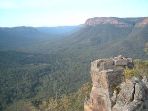
Having completed a designated search area in Nattai NP wilderness area, we discovered a way of ascending the mountain
in an area where access had not initially appeared possible. After considerable effort to reach the top of the mountain, we
were totally smashed by the time we achieved our objective.
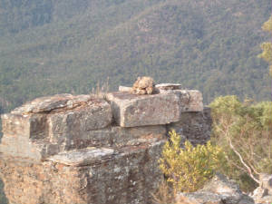
In an area where absolutely no-one ever goes, I got quite a surprise to see two man made rock formations situated on
an isolated precipice overlooking the valley. Both were intricately constructed, one being dome-like and the other a
square formation. I intially considered possibility of a wounded survivor having made the markers, however the absolute inaccessibity
of the site (my access was prevented by a 2.5m gap & a 15m drop) rendered this as unlikely. An alternate possibility considered
at the team was construction by members of Barralliers party who I believe came thru this area in 1802, which
would then render it of historical significance.
There are many other possibilities, such as:
1. Aboriginal spiritual marker
2. Aboriginal water/route marker
3. Timber workers (we also located an old Vulcan vintage truck (burnt out) in heavy bushland, about 3km from the
site.
4. Forestry workers or Rangers
5. Surveyors
6. Hikers/wilderness country travellers
The list is endless. I ruled out 3, 4 and 5 due to the nature of construction of the markers and the risk involved
in constructing them (a log would have been needed to cross the 2.5m gap). No.3 particularly was ruled out, as there is no
way timber could have been brought down from that location on the mtn. No. 6 is also unlikely due to the extreme remoteness
and its distance from the Katoomba to Mittagong trekking route.
Aside from possibility of a survivor of the Dragon, this leaves options 1 or 2 as being most likely. The access route
we found could potentially have been used by aboriginal peoples to obtain access up/down the mtn and for water from Nattai
River.
The survivor scenario is unlikely, but still possible. I've ruled it out however due to searches of the area and access
issues for a wounded person to get to that specific site. Close-by is a virtually impenetrable rock wall and gully. Myself
and other team members have had a reasonably good look around accessible areas in that location at a later time, but
nothing of interest was located.
I reported the location to SCA and NPWS not long after, but neither contacted me in relation to the items.